
Muskoka's Elastic Borders
Article by J. Patrick Boyer
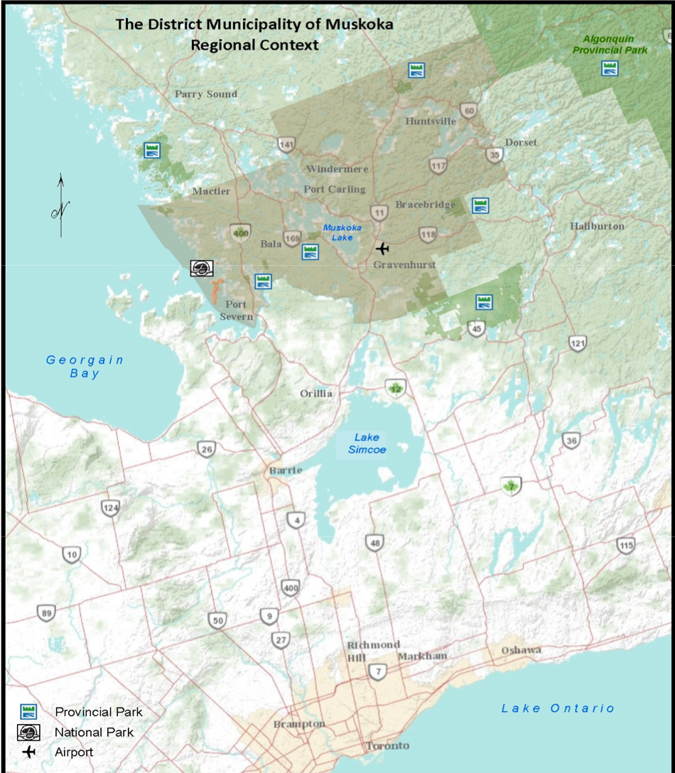
Looking at a map of Muskoka you can see its borders have not changed for a century and a half. Well, changed slightly but not so anybody today notices.
Pioneering homesteaders in the district’s northwest faced an arduous journey south to Bracebridge to register their free grant lot of land, so Humphrey Township was transferred temporarily to Parry Sound District, its conveniently closer Crown Land Office available for legal niceties. Like many temporary arrangements, Humphrey has since remained firmly welded to Parry Sound District.
A second change, at Muskoka’s northeast corner, resulted from expansion of Algonquin Park when a preference for straight boundary lines bisected unorganized Finlayson Township, its eastern half in the park, the western half in limbo. When Muskoka’s internal municipal boundaries were revamped in 1970, the orphaned half of Finlayson, still unorganized for municipal government, was quietly fixed to the District. Except for those two tweaks, losing one township but gaining half of another, Muskoka’s territorial outline has remained intact since the 1860s.
Muskoka’s borders are both natural and manmade. The western boundary, Georgian Bay’s shoreline, offers a natural edge. The district’s southern boundary, the Severn River, is also a recognizable natural boundary. However, to the east and north, where the unbroken landscape just keeps on rolling, provincial officials drew two lines across a map, inventing divisions where nature herself imposed none. One artificial break indicated where Muskoka stopped and Haliburton began, the second where Muskoka and Parry Sound districts split from one another.
These two arbitrary borders present the same tussle with Canadian Shield physicality surveyors encountered laying out Muskoka’s internal grid with many irregular property lines. Early Muskoka councils appointed lot line inspectors and refereed disputes between neighbours. Rough terrain boundaries proved fungible in nature then and today still confound many real estate transactions. When driving Highway 11 north from Huntsville or the roads around Rosseau, it’s hard to tell from the terrain where you’ve left Muskoka and entered its twin district.
If seen from above, whether by bird, aircraft or satellite camera in outer space, Muskoka spreads seamlessly east and north and even south of the Severn, unrecognizable as a mapped block because it is an integral part of a larger contiguous zone. Across the district at ground-level, frogs and otters and moose are as much at home in these woodland swamps as they’d be in the wetlands of Haliburton, Parry Sound or the continuing Canadian Shield territory beyond.
On February 28, 1868, these geographic boundaries for Muskoka were formally enacted by Ontario’s legislature when also setting borders for Parry Sound and Nipissing, all three as northern Ontario districts. It was a step to open the northlands for logging and farming, and to populate the region with a large number of Euro-Canadian settlers. The action was to prevent Americans from moving into “empty land” across the Great Lakes, fearing another invasion because Abraham Lincoln’s Secretary of State, William Seward, promoting the Manifest Destiny doctrine that all North America be part of the United States, aggressively championed Canada’s annexation.
It was no simple thing to orchestrate all this. In the 1850s, the province had already allowed logging to begin in south Muskoka, while settlers were claiming land as squatters, with little local administration and no control. The three districts had to be surveyed, challenging work that continued for decades. Despite the urgent need for municipal government, Muskoka’s embryonic townships remained northern extensions of Victoria County and Simcoe District for most purposes, townships in Muskoka’s eastern half part of Victoria, in the western half, with Simcoe. Politically, Muskoka’s internal borders were porous.
To form any municipal structure at all, scattered homesteaders improvised a frontier solution by combining lightly settled townships until their population reached the Municipal Corporations Act threshold to become a “township municipality” whose residents could elect one council serving them all, effectively making their township boundaries vanish. Early “united townships” included Draper-Macaulay-Stephenson-Ryde, Cardwell-Watt, Morrison-Muskoka, and McLean-Ridout – ten minimally populated townships become four.
Reeves in east Muskoka travelled to Lindsay for Victoria council meetings, those from the west down to Barrie for Simcoe council. The provincial government believed this doubled-up role provided life support for infant Muskoka townships but required reeves to preside over their own township’s council meetings and participate in Victoria or Simcoe councils, too. Expected to share information between elected representatives of Simcoe, Victoria, and Muskoka, few councillors in the larger centres cared about what was going on in the bush to their north and remained attentive to their own electors’ needs.
Not until 1888 did the province elevate Muskoka to provisional district status, severing the cord with Simcoe and Victoria after 20 years. This upgraded Muskoka townships so they could develop and allowed district reeves to focus on doing so, no longer having to sacrifice time and travel to be a phantom presence elsewhere.
It took decades for the three districts to come into their own and establish viable operations within their boundaries. Muskoka was either sliced and parts grafted or kept whole and joined entirely, to neighbouring jurisdictions north, east, or south. This began when the district was combined with Parry Sound to elect a representative in the House of Commons, as is again the case today for both federal and provincial elections. Muskoka and Parry Sound also formed a single district for administration of justice. Initially, Muskoka was joined with counties to the south, too, for land registration.
With time, each district enjoyed good runs as self-governing entities, with Muskoka in particular reaching its zenith by the 1950s as a fully-functioning, free-standing, and publicly recognized place with a distinct identity. In 1955, when Robert Boyer was elected Muskoka’s MPP, it was the first time the district stood on its own as an electoral district.
But then, especially through the 1970s and since, Muskoka’s boundaries again turned to jurisdictional rubber as the provincial government, deeming lines on a map artificial and irrelevant, stretched the district to fit into aggregated groups. Queen’s Park joined Muskoka to Simcoe and Haliburton counties and Parry Sound District for more and more public purposes such as education, health services, medical programs, social and family services and economic incentive programs. Muskoka had not moved but being stretched in so many different operational and administrative directions, its boundary lines on the map, with little enduring relevance, effectively vanished.
When Ian Turnbull of Port Carling served Muskokans as District Commissioner for Community Services, he, his staff and councillors interacted with surrounding jurisdictions in the same region as the district and liaised with regional headquarters. To begin, North Bay was headquarters because Muskoka was in a regional unit of northern districts. Then headquarters was Toronto because someone in the provincial government reassigned Muskoka to a group of counties all the way south to Lake Ontario. Next, Queen’s Park again reunited Muskoka with the north, but now headquarters was Sudbury.
That one example reveals the problem when extraterritorial operation of local affairs is multiplied across the entire spectrum of government, ministry by ministry. Rotation of varying partners creates paralysis in daily work and decision-making. Muskoka councillors and staff must establish working relationships with hosts of different counterparts in separate silos of government amidst changing procedures and personnel – in Haliburton with education, Simcoe for community and social services, health, administration of justice, and more. Those at Queen’s Park subdivide the province into regions for their particular ministry’s operations, causing fragmentation or duplication of effort and resources in rural communities.
Yes, viewed laterally from above, Muskoka is a single district within long established borders. However, seen horizontally, the place is sliced to shreds. The province places Muskoka, a northern district, in three different places at the same time. First, the government’s “Central Ontario Region” configuration incorporates Muskoka geographically within what, to Queen’s Park, is a larger “primary region” it calls “Southern Ontario,” which specifically brands northern district Muskoka, within that context, as part of the “south-central section” of the province.
Second, despite Muskoka and Parry Sound districts both being in so-called Central Ontario, some reality can be glimpsed from the fact that each is actually administered by public entities, including the federal government, as part of Ontario’s other primary region, “Northern Ontario.” Adding to this geographic confusion, the provincial government accords Parry Sound, but not Muskoka, administrative status as what it calls an extended primary Northern Ontario region. Third, for certain programs the provincial government deems Muskoka part of its “Eastern Ontario Region,” another Queen’s Park secondary zone, because it sees the district “as a transitional area between the geographic regions.”
Ontario’s Ministry of Municipal Affairs promotes its view that Muskoka no longer exists as one of the province’s 11 northern districts. Similarly pushing Muskoka into this twilight zone, Ontario’s Health Ministry, in mapping its administrative regions across the province, excludes Muskoka from its fellow districts, grouping it instead with all counties south to Lake Ontario and Toronto. The Ontario Municipalities Association, in lockstep, only sees 10 districts in the province, not 11.
Back in the 1970s, Muskoka’s publicized identification with wealthy summering folks made several senior civil servants in the Department of Municipal Affairs, radicalized by the 60s cultural revolution, see the district as a privileged enclave for the rich. Intent on ending all financial benefits received from Ontario’s government, based on its status as a northern district needing help, they pushed for revocation of Muskoka’s northern classification. The “North” would start at the French River, not the Severn. MPP Robert Boyer, knowing Muskoka’s realities, managed to thwart that ill-informed gambit.
But for half a century, the tug-of-war over reclassifying Muskoka as part of southern Ontario has continued. Ten years ago, Muskoka was removed from the Northern Ontario Heritage Fund, the Northern Health Travel Grant Program and all other northern programs. This year, Northern Ontario Heritage Fund Corporation, a provincial operational service agency, reinstated Muskoka to receive economic development funds.
Although the territorial borders of Muskoka, enacted by the legislature and established by settler society a century and a half ago, may now seem a time-trapped aberration, appearances are often deceiving. Muskoka registered on North America’s social map and even imprinted itself onto psychological projections of people across the continent, through the human phenomenon of identifying with place.
Achieving “a Muskoka state of mind” or becoming entranced by “the Muskoka Mystique” is neither focused on, nor confined by, formal geographic boundaries. By bonding with the place’s uniqueness, “Muskoka” became a treasured destination as people far distant established a sense of belonging to what, in 1914, Prime Minister Robert Borden, speaking at Port Carling about Muskoka, called “this far-famed district.”
Muskoka’s northland character atop the southernmost exposed section of the Canadian Shield’s rocky lakelands and forests proved convenient for those in other areas craving some place special, sparking the district’s vacation economy. Government officials and land promoters in the mid-1800s envisaged only logging, farming, and manufacturing. Yet deeper patterns will out. Summer holidaying had been part of Indigenous life in this area for time beyond memory, with First Nation peoples returning year after year to Beausoleil Island (now in Muskoka’s Georgian Bay Township) and Trading Lake (now Lake of Bays.)
Muskoka’s borders are now stretched in new ways by telescoping through time. Relentless exploration and discovery, advancing mapping technologies and the ability to photograph Earth from outer-space and its’ ocean bottoms from deep below the waves, cause constant updating of maps. With digital technology, the ability to integrate a wide range of data about the same site, for which Muskoka’s online GeoHub is a stellar example, further enhances maps and records. GeoHub enables people anywhere on earth to access through cyberspace in a single location the mash-up of the 1876 Guide to Muskoka, changing water levels through time, almost limitless amounts of municipal data, even projections of how one’s property might look in the future if certain structures and changes, modelled on the screen, were implemented – a triumph of elastic borders.
This free-floating awareness of Muskoka, unhinged from the district’s official borders, runs back millenniums with Indigenous wayfinders arriving from the Severn River and its distant reaches to enter a large lake and be nourished by its enthralling unmeasured realms.
In 2022, Indigenous leaders developing the Misko-Aki: Confluence of Cultures exhibit on the very same Lake Muskoka bay at Gravenhurst required a much larger area than “official” Muskoka to illustrate their lived heritage on this territory inland from Georgian Bay. Taking a millenniums-long view, their account embraces land known to different First Nations and used by them for thousands of years, the territory of today’s “Greater Muskoka.”
The timeless elasticity of Muskoka’s borders teaches they are inconsequential for a place that is a crossroads community. The district has long been both meeting place and shock-absorber for values of the metropolis and practices of the hinterland.
Reflecting on the broad scope Muskoka’s place in Ontario, Ian Turnbull draws from his experience to emphasize this facet of being between. In his work with the District, “I came to understand this betweenness in many ways. With our fabric of small towns and seasonal economies we were more like Parry Sound and Algoma Districts than Simcoe County and burgeoning urban areas to the south. Yet we had a regional government, distinguishing us from our friends to the north and aligning us with regional municipalities in Ontario.” He adds, “We shamelessly adopted best practices from north and south to Muskoka’s benefit. We innovated program delivery as a small regional municipality in ways smaller and larger entities couldn’t.”
Accepting Muskoka as “a land between” is essential for the district’s future. “There were some benefits to our betweenness in the first three decades of district government,” Turnbull concludes, while pointing out that “Queen’s Park couldn’t fathom it and switched program funding mechanisms north/south and vice versa over time, to our benefit/detriment.”
In recent decades, failure to recognize Muskoka’s unique location betwixt others – socially and culturally a one-off in Ontario, the only jurisdiction having two-tier municipal government within a district – caused distant officials to confound proper municipal functioning by making the district a larger catchment area for such community-centric realms as schools and public health, simply by mistaking elasticity for invisibility.